
Case Study: California State Coastal Conservancy
Gravel Beach and Berm for Shorebird Habitat Creation, Erosion Control and Flood Protection
Table of Contents
- Key Information
- Transferable Strategies
- Project Overview
- Challenges and Solutions
- Print this Case Study
Key Information
| Project Type | Site assessment and preliminary design | ||
| Theme | Adaptive management: The California State Coastal Conservancy developed an adaptive management plan that was used from the onset of a pilot project to design a 300-foot, nature-based feature. Their approach included designing and implementing a robust monitoring protocol to assess site feasibility challenges and inform implementing the pilot project and scaling the project from a 300-foot feature to a one-mile feature. |
||
| Keywords | Flood protection, risk reduction, levee breaching, tidal wetland restoration, salt ponds, migratory birds, tidal marsh | ||
| Organization (Type) | California State Coastal Conservancy (Government organization) | ||
| Project Contacts (as of 2022) |
Laura Cholodenko, Project Manager, Laura.Cholodenko@scc.ca.gov Tim Clark, Project Manager, tim@scapestudio.com |
||
| Award Amount1 and Year | NFWF Award: $237,405 | Match: $238,000 | Award Year: 2018 |
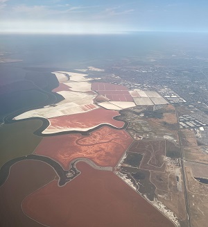
| Location | Eden Landing Ecological Reserve, South San Francisco Bay, Alameda County, California |
||
| Partners | SCAPE Landscape Architecture, Arcadis, Ducks Unlimited, California Department of Fish and Wildlife | ||
| Multimedia and Additional Links2 |
Project website: South Bay Restoration Additional project overview website: Eden Beach Project |
||
1 The award amount does not necessarily reflect the total project cost. The match amount is based on the project proposal information. 2 Disclaimer: The opinions expressed in the multimedia and additional relevant links are those of the project team and their partners only and do not necessarily reflect the views of the National Fish and Wildlife Foundation (NFWF).
Transferable Strategies from this Case Study
- Conduct pre- and post-project monitoring: Monitoring is a key component of an adaptive management approach. It allows project teams to study how a project or system is responding over time and determine which interventions, if any, are needed to achieve the desired outcomes. However, it can sometimes be difficult for teams to secure funding for pre- and post-project monitoring, and teams may feel they lack the capacity to conduct a robust monitoring program. If funding is unavailable for a more robust program, simple monthly site walkthroughs to conduct high-level visual assessments can still be an effective technique for observing how a project site is functioning over time.
- Supplement modeling with local knowledge: Digital cross-shore modeling could be a helpful tool in developing new forms of shoreline protection throughout the San Francisco Bay area or other coastal areas with similar geological and environmental features. However, using these models to inform nature-based shoreline features is still a relatively new process. Therefore, it can be helpful to combine modeling outputs with the knowledge of local area experts.
- Communicate with regulators: Communicating frequently with regulators to help them understand the proposed project approach and its benefits can help ensure timely permit approval. Regular communication can also help the project team respond quickly to additional information requests or design changes, thereby avoiding timeline delays.
Project Overview: Gravel Beach and Berm for Shorebird Habitat Creation, Erosion Control, and Flood Protection
|
A team of nonprofit organizations and government agencies led by the California State Coastal Conservancy developed preliminary design plans to use a gravel beach and berm in the Eden Landing Ecological Reserve to protect critical habitat, control erosion, and enhance shoreline resilience on the south San Francisco Bay.
The gravel beach and berm is a 300-foot, nature-based pilot project designed to protect an existing levee from erosion while stabilizing the shoreline and providing multiple ecosystem services. Outcomes from the pilot project will inform implementation of a one-mile gravel beach and berm at the same location and will serve as a model for similar projects along the San Francisco Bay shoreline. The project is part of the larger South Bay Salt Pond Restoration Project Phase 2, a multi-partner effort to restore and enhance more than 15,000 acres of former industrial salt ponds to a rich mosaic of tidal wetlands and other habitats.
Challenges and Solutions
To determine feasibility of the proposed gravel beach and berm, the team conducted a thorough site analysis and went through multiple design iterations after encountering various geotechnical challenges and model limitations. By developing an adaptive management approach from the onset, including a robust monitoring protocol, the team addressed these challenges and adjusted designs to reach their goals. The team will continue to adaptively manage the beach and berm site following installation of the beach and berm.
Limitations of Model Outputs
Challenge:
To inform site selection for the project, the team studied surrounding land use patterns, topography, bathymetry, hydrology, geology and soils, erosion and cross-shore sediment transport patterns, and other parameters. Wave analysis and digital cross-shore modeling were also integral to informing the designs. However, the model was unable to predict certain site-specific outcomes such as wave refraction1 from nearby levees or the impact of longshore transport2 on the proposed designs. In addition, preliminary geotechnical evaluations indicated that the proposed placement of the beach and berm feature would be on soft, highly compressible soils, which could cause the feature to fail over time. Addressing these challenges was critical to developing the designs and monitoring plan.
Solutions:
- Ground-truth model outputs: The team’s local experts ground-truthed the model outputs to address specific geotechnical concerns. In particular, they conducted soil sampling at the project site, which revealed a more stable soil profile than originally identified through available published information.
- Design and pilot different approaches: Due to the complicated site geology and the need to ensure the site will be able to support the berm structure, the team developed multiple versions of the beach and berm design.
- The team will use the pilot to test the different designs and identify the most stable, ecologically valuable, and cost-effective design to use when implementing the one-mile gravel beach and berm project.
- Develop an adaptive management plan, including pre- and post-project monitoring: Monitoring is integral to adaptive management. The team will use monitoring data from the pilot project to confirm model outputs, better understand the feature’s overall stability and rate of settlement, and assess its biological performance. Monitoring results from the pilot will also inform the design specifications of the one-mile feature. Following implementation of the one-mile feature, post-project monitoring will guide ongoing management.
Regulatory Constraints
Challenge:
|
The BRRIT was established in 2019 by the San Francisco Bay Restoration Authority. It is composed of seven state and federal regulatory agencies that have jurisdiction over ecological restoration projects in the San Francisco Bay. The BRRIT was designed to improve and streamline permitting processes for multi-benefit wetland restoration projects and their associated flood management and public access infrastructure features. Projects must be located within the nine Bay Area counties. |
In California, state and regional permitters generally support nature-based shoreline resilience features. However, constructing the gravel beach and berm will require placement of sediment material in San Francisco Bay waters, which federal and state regulations, such as Sections 401 and 404 of the Clean Water Act, limit. As a result, the team faced a lengthy permit application process.
Solutions:
- Promote strong and regular coordination with regulators: The project team had the opportunity to coordinate with the BRRIT, a multi-agency team that helps streamline permitting for voluntary Bay Area wetland restoration projects (see box). The BRRIT facilitated pre-application meetings and site visits to increase regulators’ understanding of the project and its goals. It also facilitated ongoing communication between permitters and the project team.
1 Refraction is defined as “the changing in direction of waves as they move between materials with different properties.” University of Hawaii, 2021.
Wave-Coast Interactions. Exploring our Fluid Earth. Available at: https://manoa.hawaii.edu/exploringourfluidearth/physical/coastal-interactions/wave-coast-interactions
2 Longshore transport is defined as the “cumulative movement of beach and nearshore sand parallel to the shore by the combined actions of tides, wind, and waves and the shore-parallel currents produced by them.” Morner, N.-A. et al., 2005. Longshore sediment transport. Encyclopedia of Coastal Science, pp. 600-600.
Print this Case Study (PDF version)